|
|
|
|
|
The Ming Voyages -- Maps(Travellers | Cities | Routes | Trade Goods | Themes)
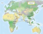
There are two types of map available for this module: historical maps produced at or near the time of the voyages, and modern maps created to illustrate the various aspects of the subject. The largest and most interesting historical map has be come known as the "Mao Kun map" since the study by J. V. G. Mills. Published in Chinese as Zheng He hanghai tu (Map of Zheng He's Navigation of the Seas), its earliest appearance in print in 1621 was as juan 220 of Mao Yuanyi's Wubei zhi (Treatise on Military Preparedness). It consists of wood-cut drawings of the journey in 40 folios.
|
The Ming Voyages |